Caithness
|
|
|
|
Caithness
|
||||||
|
|||||||
|
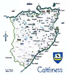
(Click on the picture to see a larger one) Like Orkney just to the north over the wild waters of the Pentland Firth, Caithness has many monuments confirming its settlement by prehistoric man. The Great Cairns of Camster are over 4500 years old, and provided you don't mind scuffing your shoes and the knees of your trousers, you can still crawl through the cramped entrance tunnels to the main chamber of the Long Cairn. It's thought that the cairns were built as burial places by a people who worshipped a "Mother Earth" goddess. Later came the Picts, who in turn left many of their mysterious symbol stones to record their passing. From the 9th century onwards they were ousted by Norse invaders, and it was not until 1196 that king William the Lion manageed to assert the authority of the Scottish Crown, although the Norse Earls of Orkney retained considerable influence until well into the 13th century. In medieval times the St.Clair (now better known as the Sinclair) family established their authority in the county. Initially from Normandy in France, they came to Scotland in the 13th century and, having fought for Robert the Bruce at Bannockburn, were granted lands at Pentland as their reward. In the 14th century Henry St. Claire acceded to the earldom of Orkney, and then proceeded to conquer the Faroe Islands before discovering Greenland and almost certainly travelling on to North America, where he is thought to have landed in both Nova Scotia and Massachussets, long before Christopher Columbus made his epic voyage to the New World. In the 15th century the Sinclairs were granted the earldom of Caithness, but lost it in the 17th century when Sir George Sinclair, the sixth earl, who had been forced to sell off most of the family lands, died without issue. Sir John Campbell of Glenorchy was the chief mortgagee of the Sinclair estates and he promptly married Sir George's widow and claimed the earldom for himself. This did not go down well with the rest of the Sinclair family and George Sinclair of Keiss besieged and captured Girnigoe Castle, which was claimed by the Campbells. The Campbells had swift revenge at the bloody battle of Altimarlech, where so many Sinclairs were killed that the Campbells were able to cross the river without getting their feet wet. Clearly, however, the Sinclairs had influence in high places as only a few years later, in 1681, they regained the earldom by an order of Parliament. Girnigoe Castle, dramatically situated on the cliffs just outside Wick, was one of the main Sinclair strongholds. Although now ruined, it is well worth a visit and it still contains both a secret chamber in the vaulting of the kitchen ceiling and a grim dungeon where, it is said, the 4th Earl of Caithness imprisoned his son and heir and fed him salt beef so that eventually he died mad with thirst. Another former Sinclair property is the Castle of Mey, originally known as Barrogill Castle. In the early 1950s the castle was purchased by HM The Queen Mother who changed its name back to Castle of Mey. The castle is reputedly haunted by The Green Lady, ghost of a daughter of the 5th Earl. Having fallen in love with a local ploughman, the unhappy girl was imprisoned in the castle attic by her angry father and, in a fit of despair, she threw herself from a window. Caithness is the most northerly mainland county in Great Britain, but the most northerly point is at Dunnet Head, where 300 ft high cliffs drop sheer to the sea. Nearby John o' Groats was named after the de Grot family, who came to Caithness from Holland late in the 15th century. At Canisbay Kirk there is a de Grot family tombstone dating from 1568. At the turn of the 19th and 20th centuries, flagstone quarrying was the major industry in Caithness employing over 1000 men and exporting Caithness flags as far afield as Australia and South America. There were many quarries, the first having been at Castlehill, but due to the introduction of concrete most of the Caithness quarries closed in the 1920s although today small scale quarrying of high quality stone continues at Spittal and Halkirk. The county's other major industry was fishing - in the 19th century Wick was the largest herring fishing port in Europe. Today, the Dounreay atomic reactor just outside Thurso (the most northerly town on the British mainland) is the county's greatest source of employment. Family names associated with Caithness include Sinclair, Gunn (the Clan Gunn Heritage Centre is at Latheron), Oliphant, and Keith. The Mearnscraft map of Caithness has a stich count of 148 x 162 and when stitched on the recommended 27-count Linda evenweave measures 10½ x 11½ inches (269 x 294 mm). As well as the usual landscape features, place names, compass and crest it includes 31 buildings, lighthouses, ferry, and fishing and sailing boats.
|
|||||||||||||||||||||
|
Mearnscraft
|