Stirlingshire
|
|
|
|
Stirlingshire
|
||||||
|
|||||||
|
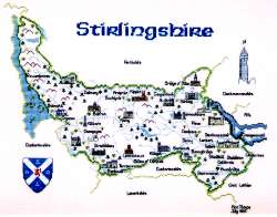
(Click on the picture to see a larger one) Stirlingshire lies in the very heart of Scotland and is bounded by Dunbartonshire, Lanarkshire, West Lothian, Parthshire and Clackmannanshire. Loch Lomond, which is partly in the county, forms much of the western boundary, and Ben Lomond is its highest mountain. Just as it lies at the nation's geographical heart, so Stirlingshire also takes a central place in its history. The county town of Stirling stands at the highest navigable point of the River Forth and guards both the principal north-south and east-west routes through Scotland and since time immemorial a fortress has stood on the volcanic outcrop that overshadows the burgh. During the wars of independence Stirling Castle changed hands several times - Wallace secured it in 1297 by beating the English at the Battle of Stirling Bridge, it was in English hands again the following year, then it was retaken by the Scots before falling to the English again after a siege in 1304 when Edward I used fire throwing equipment and a siege machine called the War Wolf. By 1313 Stirling was one of only three Scottish castles still held by the English and it was basically for control of the castle that the decisive Battle of Bannockburn was fought virtually under its walls in 1314, with Edward II's 20,000 strong army being outwitted and slaughtered by Robert Bruce and his 7,000 troops. To the south of Stirling lies Falkirk, a largely industrial town where, in 1298, Wallace and his troops were comprehensively defeated by Edward I's powerful and much larger army. (And if you want to know where California is, it's a village just a few miles south of Falkirk). During the succeeding
centuries Stirlingshire continued to see battles, bloodshed, and a continuing
quest for power by the nation's most powerful men. At the Battle
of Kilsyth in 1645 the royalist James Graham, Marquis of Montrose, defeated
General Baillie's covenanting army, but by 1651 Oliver Cromwell's parliamentarian
army had taken Stirling Castle. Then in 1715 the Battle of Sheriffmuir
took place between the Jacobite forces of John 6th Earl of Mar and the
pro-Hanoverian army of John 2nd Duke of Argyll. This battle was
inconclusive, with victory going to neither side - as the anonymous
balladeer put it:
Family names associated with the county include Stuart, Graham, Buchanan, MacGregor, Livingston, Erskine, Elphinstone, Cunningham, and Bruce. Our map of Stirlingshire measures 14¾ x 11¼ inches (376 x 286 mm) when stitched on the rocommended 27-count Linda evenweave material and has 20 buildings, place names, county crest, and the Wallace Monument as the compass. Stitch count is 200 x 152.
|
|||||||||||||||||||
|
Mearnscraft |