Clackmannanshire
|
|
|
|
Clackmannanshire
|
||||||
|
|||||||
|
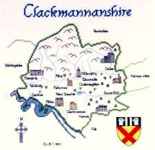
(Click on the picture to see a larger one) Clackmannanshire took pride in the fact that it was Scotland's smallest county (it comprised 34,838 acres). Lying on the north bank of the River Forth, Clackmannanshire was bordered by Stirlingshire to the west, Perthshire to the north and Fife to the east. The county council motto was the rather curious phrase "Look aboot ye"; the story behind this is that when Robert the Bruce was paying a visit to the area, he inadvertently left his gauntlet (a "mannan") on a stone (a "clach") and sent his squire back to look for it with the instruction "Look aboot ye". Until 1822 the small town of Clackmannan was the county town. It's now ruined castle, Clackmannan Tower, was a Bruce property, the land on which it stands having been granted to Robert Bruce, an illegitimate grandson of King Robert the Bruce, in the 14th century. It's last occupant, Lady Catherine Bruce, retained Bruce's great double-handed sword and at parties she sometimes used this to "knight" favoured guests. Included among these was Scotland's national bard, Robert Burns. The Tower is now an impressive ruin, albeit unstable due to mining subsidence. Alloa has been the county town since 1822. It was the home of the Erskines of Mar, who built Alloa Tower which at one time formed the centre of a palatial complex. The Erskines, later created Earls of Mar, were once one of the greatest families in the land, and the 6th Earl, John, was Secretary of State for Scotland under Queen Anne and was later renowned for his grovelling sycophance towards the Hanoverian George I. However, following a Hanoverian snub, he raised the Jacobite standard of James Edward Stewart (The Old Pretender) in 1715 but unfortunately proved an inept military leader. Following the failure of the rebellion he forfeited his estates and title and fled to France. Apparently the unfortunate Earl was popularly known as "Bobbing John" because of his habit of changing sides. Family names associated with the county include Erskine, Bruce, Colville, and Campbell; the impressive but ruined Castle Campbell, just outside Dollar, was once more sombrely known as Castle Gloom (or Gloume) and lies by the Burns of Care and of Sorrow. Our map has a stich count of 130 x 134 and, when stitched on the recommended 27-count Linda evenweave, measures 9½ x 10 inches (244 x 252 mm). There are 8 buildings, place names, compass, and crest.
|
|||||||||||||||||||||
|
Mearnscraft |